NeerVerse
A unified geospatial intelligence platform that integrates real-time hazard detection, AI-powered social media analytics, and interactive disaster mapping for comprehensive emergency response
A unified geospatial intelligence platform that integrates real-time hazard detection, AI-powered social media analytics, and interactive disaster mapping for comprehensive emergency response
Real-time visualization of natural hazards and climate data across South Asia using advanced satellite imagery and earth observation technology.
Empower communities to report hazards in real-time with our intuitive reporting system
Automatically capture precise location data for every report with GPS integration
Upload photos and videos to provide visual context for hazard reports
Reports are processed instantly and verified through AI-powered analysis
Multiple reports from the same area are cross-verified for accuracy
Real-time updates from citizens, rescue teams, and authorities about ongoing disasters and hazards
⏱ 2 minutes ago 📍 Mumbai, Maharashtra
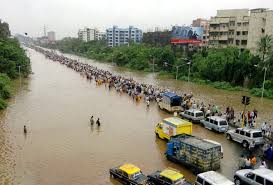
Heavy rainfall reported in Andheri area. Water logging in rural areas. Avoid this route if possible. Emergency teams deployed.

⏱ 15 minutes ago 📍 Chennai, Tamil Nadu
Cyclone Michaung approaching coast. Strong winds already felt. All residents in coastal areas please move to safer locations immediately.
Real-time updates from citizens, rescue teams, and authorities
Fetching latest hazard alerts...
Click "Refresh Feed" to start monitoring hazard alerts from X (Twitter).